

Squawkr opened to the public on 19 September. It brings airfield information, local weather, crosswind and restriction areas into one app, so you can decide on a flight without reading coded text. It runs in your browser, goes on your phone's home screen with this core functionality available for free.
The information you need before a flight is spread across several sources, and much of it arrives as METAR, TAF and NOTAM code. Squawkr collects it and works it out for you. It suggests the best runway, plots the actual crosswind, shows which restriction areas are active or scheduled, and shows sky conditions in an altitude chart.
At a glance
| Released | 19 September 2026 |
| Open it | Open the app in Safari on iPhone, Chrome on Android or any desktop browser |
| Price | Free, including the account |
| Weather and runways | Airfields worldwide, wherever a METAR or TAF is published |
| Restriction areas | Sweden and the United States |
| Languages | English and Swedish |
What's in the first release
Airfield info
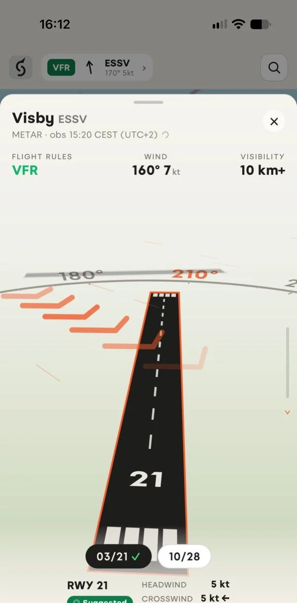
Open an airfield and you get a 3D view of the whole field at true scale, a satellite view and its runways. Airfields without a weather station still show runway details. The closest airfield data always sits in a widget at the top of the map, one tap away.
Local weather
Squawkr decodes the latest METAR into flight rules, wind and gusts, visibility, cloud base, temperature and pressure. Swipe for sky conditions, with the cloud layers drawn on an altitude chart. TAF data becomes a timeline for conditions in the hours ahead. Raw METAR and TAF are always there, exactly as issued.
Crosswind
Squawkr picks the runway that suits the wind and marks it as suggested. For every runway it shows the headwind/tailwind and crosswind, gusts included. In the 3D view the wind flows across the runway you are looking at.
Restriction areas
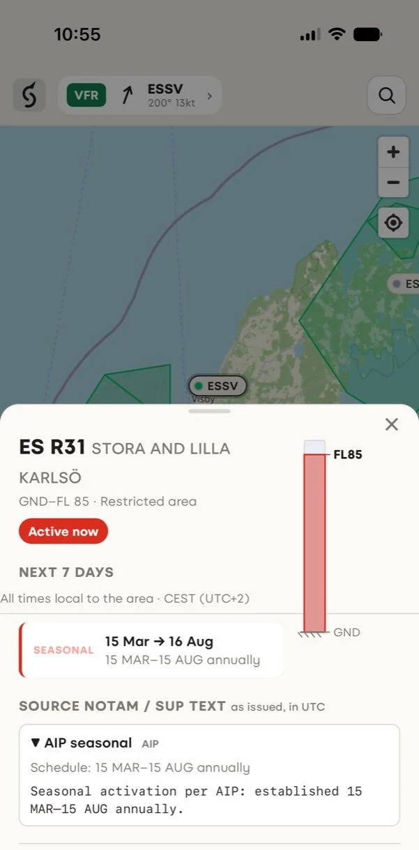
In Sweden and the United States every restriction and danger area on the map has a colour. Red means active now. Amber means scheduled later today or this week. Green means no activation has been published.
Tap an area to see its vertical limits drawn to scale, a timeline of its activation windows for the next seven days and the source NOTAM text as issued. Where areas overlap, the app lists them all and draws their heights on one scale. In Sweden the map also shows control zones with their class, limits, sectors and reporting points.
Times in local time
Every time is in the local time of the place it describes, the airfield for weather and the area for activations, with the zone next to it, as in 13:50 CEST (UTC+2). Squawkr handles summer time.
Data you can check
Every answer shows how old it is. If a source is slow, Squawkr shows the copy it already has at once and refreshes it in the background. If the data gets old, a banner says so. When you lose coverage, the app keeps showing the last data it fetched and labels it as a stored copy.
Search, share and install
Search airfields by name, ICAO or IATA code, and restriction areas by designator or the place they cover. Share any airfield or area as a link that opens straight to it. Add Squawkr to your home screen and it opens full screen, like any other app, and updates itself. If something looks wrong, report it from the airfield or area. The report includes what you were looking at and how old the data was, but not your location.
A free account
You can open five airfields and areas without an account. After that you need a free account. You sign in with a six-digit code or a link sent by email, with no password, and the app remembers where you last looked.
Coverage
| Territory | Weather and runways | Restriction areas | Activation status |
|---|---|---|---|
| Sweden | Yes | Yes | Yes |
| United States | Yes | Yes | Yes |
| Elsewhere | Yes | Not yet | Not yet |
In Sweden, Squawkr shows restricted and danger areas, temporary areas from AIP supplements and control zones, and checks for new activations every five minutes. In the United States we show about 1,200 special-use airspaces across the whole country and check the FAA's NOTAMs every three minutes. Everywhere else we have runways for about 19,000 airfields and the weather wherever a METAR or TAF is published.
Outside Sweden and the United States the map shows no restriction areas. That means we have no data there yet, not that nothing is active. We will add territories one at a time, and the places people look for coverage will help us decide what to prioritise.
Data comes from LFV in Sweden, the FAA in the United States, aviationweather.gov and OurAirports.
Before you fly
Squawkr is not an official flight briefing. Always verify activations and NOTAMs with the official source for the territory you fly in and check signs on site for ground access.
Questions or ideas? Write to hello@squawkr.net.